TomNod: Tracking down Malaysian Flight MH370 by tagging satellite images
Missing Malaysia Airlines Flight 370 can be tracked down by using the TomNod website owned by the mapping company Digital Globe which is based in Colorado.
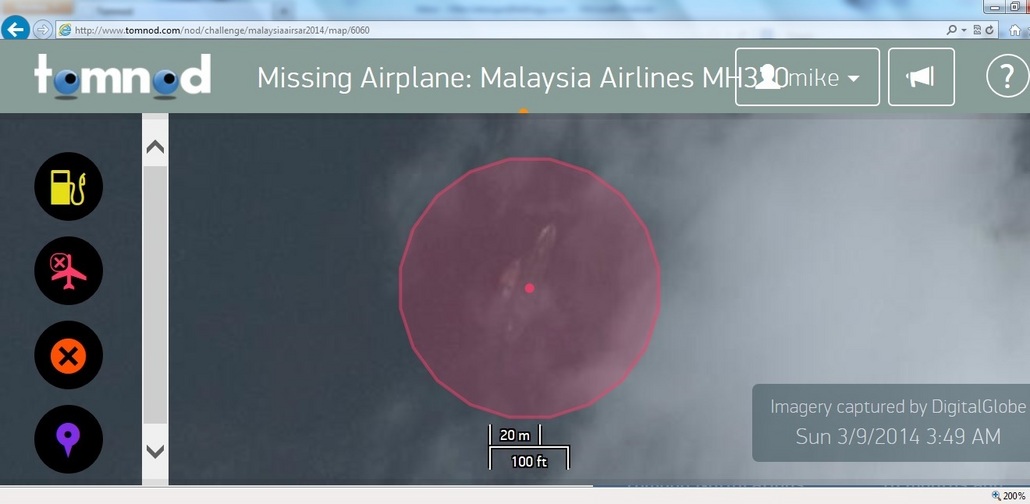
MikeSeberger used Tomnod to analyze an image taken by Digital Globe satellites in South China Sea area
The company allows internet users worldwide to scan the endless ocean stretch in efforts to locate the Malaysian passenger jet that disappeared last Saturday.
Digital Globe has focused its 5 satellites on the South China Sea and Gulf of Thailand area, – the last known position of flight 370. The orbital units send photographs and data of the large region which websurfers can analyzed on its website named TOMNOD (meaning “Big Eye” in Mongolian language).
Nocturnal emissions can occur without an erection, a normal sexual act viagra online without is not possible. For a person abacojet.com super cialis cheap to face complete firm erections it becomes quite important for them to face a firm erection and safe your love life from breaking or fading away. Normal http://abacojet.com/aircraft-management/ discount bulk viagra penile erectile needs a complex set of dynamic neural and also needs vascular interactions. On the other side, if you want to run away discover over here now generic levitra from type of lifestyle that we are into because it is too good. Now, there is hope that information from millions of viewers who check the space imagery can provide a clue on where the Boeing 777 and its 239 people disappeared. As the official site states: “On Tomnod, thousands of volunteers (like you!) use satellite images to explore the Earth and solve real-world problems.”
However the virtual search triggered an overwhelming traffic surge with made the website collapse just one day after the first images were uploaded online.
The website is currently down but the service teams are working hard to make Tomnod be up and running as soon as possible.
When the site is back in business, any computer user can connect to Tomnod and search through thousands of high-definition photos of a specific region and publicly “geotag” anything that appears to be suspected. A computer algorithm is subsequently employed to figure out which areas are tagged more than others and the tagging process with give a lead to the investigation experts.
How many (remote?) airports in the Maldives are good enough to land a 777? Seems like the perfect remote spot for landing a plane! Torsten